Banking Current Affairs
TABLE OF CONTENTS |
| National |
|---|
|
|
|
Key Highlights:
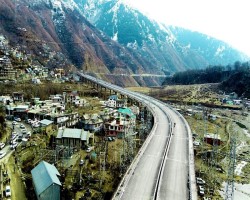
Event: The newly constructed 2.35-km four-lane Banihal bypass in Jammu and Kashmir’s Ramban district was inaugurated on Sunday. Purpose: The bypass aims to boost national security logistics and tourism while significantly reducing travel time to the Kashmir Valley. Details: Strategic Importance: Located on the Ramban–Banihal section of NH-44, the bypass is a critical upgrade to India’s longest highway, stretching from Srinagar to Kanyakumari. It resolves bottlenecks caused by roadside markets and shops in Banihal town. Ensures smoother traffic flow for tourists and defence vehicles heading to the Kashmir Valley. Infrastructure Details: Constructed at a cost of ₹224.44 crore. Initially, two-lane traffic will be permitted, with four-lane operations commencing after junction development within 15 days. Features upgrades such as tunnels and improved road quality to ensure all-weather connectivity. Impact on Travel: Travel time on the Jammu–Srinagar National Highway (290 km) has reduced from nine hours to six hours due to recent enhancements like tunnels and bypasses. Ongoing work on the 32-km Ramban–Banihal stretch is expected to further improve travel time and connectivity to the Kashmir Valley. Statements by Officials: Nitin Gadkari, Union Minister for Transport and Highways, described the bypass as a milestone for the region, emphasizing its role in improving regional connectivity, national security logistics, and tourism. National Conference MLA Sajjad Shaheen inaugurated the bypass, highlighting its potential to transform travel in the region. Significance: National Security: Facilitates faster movement of defence vehicles, ensuring readiness and logistics in the sensitive region. Tourism: Enhances access to the Kashmir Valley, promoting tourism and boosting the local economy. All-Weather Connectivity: Overcomes challenges posed by the hilly terrain of Ramban district, ensuring seamless travel. The Banihal bypass is part of a broader infrastructure upgrade by the Government of India to ensure that NH-44 remains an efficient and all-weather road connecting Jammu and Kashmir with the rest of the country. It marks a significant step toward regional development and strategic infrastructure improvement. National Highway 44 (NH-44) and Its Importance: NH-44, stretching 4,112 km from Srinagar to Kanniyakumari, is India's longest highway traversing 11 states/UTs. It serves as a crucial artery for the nation, connecting key regions and facilitating economic growth, tourism, and national security. NH-44 is not merely a road; it is a lifeline connecting India's north and south, driving economic growth, fostering tourism, and ensuring national security. Its ongoing development is crucial for the nation's progress and integration. 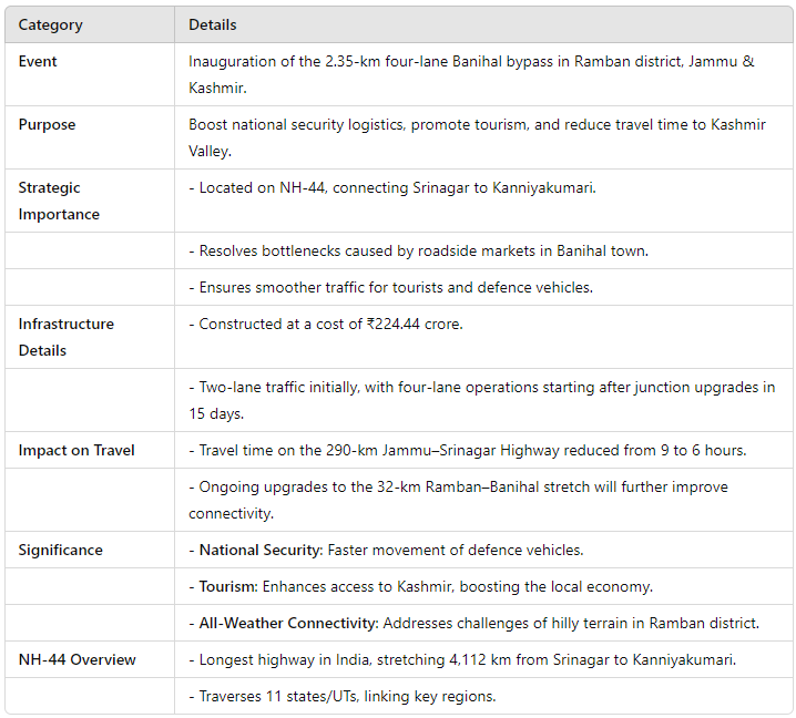
|
|
|
|
Frequently Asked Questions (FAQs) in Competitive Exams:
Question 1 What is the primary purpose of the newly constructed Banihal bypass in J&K? A) To connect Banihal with Srinagar directly B) To enhance national security logistics and tourism C) To reduce the number of road accidents in the region D) To bypass NH-44 entirely Answer: B) To enhance national security logistics and tourism Question 2 Which section of NH-44 is the Banihal bypass located on? A) Srinagar–Jammu section B) Ramban–Banihal section C) Srinagar–Kanyakumari section D) Udhampur–Ramban section Answer: B) Ramban–Banihal section Question 3 What is the length and cost of the Banihal bypass recently inaugurated in J&K? A) 5.5 km; ₹500 crore B) 2.35 km; ₹224.44 crore C) 10 km; ₹300 crore D) 3.25 km; ₹350 crore Answer: B) 2.35 km; ₹224.44 crore |
| Environment |
|
|
|
Why in the news?
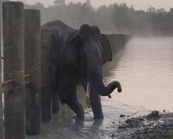
An elephant, which was stuck for nearly an hour in a rail barrier in the Veeranahosahalli range of the Nagarahole Tiger Reserve in Mysuru, was rescued before it safely made its way back to the forest About Nagarhole National Park It is also known as ‘Rajiv Gandhi National Park. It was established as a wildlife sanctuary in 1955 and was upgraded into a national park in 1988. It was declared as the 37th Tiger reserve under Project Tiger in 1999. The Park lies in the Western Ghats and is a part of the Nilgiri Biosphere Reserve. The Nagarahole River flows through the park, which joins the Kabini River which also is a boundary between Nagarahole and Bandipur Ntional Park. Flora: The vegetation consists mainly of moist deciduous forests with predominating trees of teak and rosewood. Fauna: Asian elephants, chital (spotted deer), Indian mouse deer, gaur, stripe-necked and ruddy mongooses, grey langur, bonnet macaque, Asian wild dog, leopard, tiger, sloth bear among others. 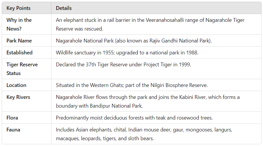
|
|
|
|
Frequently Asked Questions (FAQs) in Competitive Exams:
Question 1 Which of the following rivers flows through Nagarahole National Park? A) Kaveri B) Kabini C) Nagarahole D) Both B and C Answer: D) Both B and C Question 2 Consider the following statements regarding Nagarahole National Park: 1. It is a part of the Nilgiri Biosphere Reserve. 2. It was declared a tiger reserve under Project Tiger in 1999. Which of the above statements is/are correct? A) Only 1 B) Only 2 C) Both 1 and 2 D) Neither 1 nor 2 Answer: C) Both 1 and 2 Question 3 Consider the following statements about Nagarahole National Park: 1. It was established as a national park in 1955. 2. It features predominantly moist deciduous forests with teak and rosewood trees. 3. The park is home to species like Asian elephants, tigers, and sloth bears. Which of the above statements is/are correct? A) Only 1 and 2 B) Only 2 and 3 C) Only 1 and 3 D) All of the above Answer: B) Only 2 and 3 Question 4 Consider the following statements about the rivers in Nagarahole National Park: 1. The Nagarahole River joins the Kabini River, which forms a boundary between Nagarahole and Bandipur National Parks. 2. The Kabini River originates in Nagarahole National Park. Which of the above statements is/are correct? A) Only 1 B) Only 2 C) Both 1 and 2 D) Neither 1 nor 2 Answer: A) Only 1 Question 5 Consider the following statements regarding the flora and fauna of Nagarahole National Park: 1. The park features predominantly evergreen forests. 2. It is home to species like the stripe-necked mongoose and bonnet macaque. 3. The park is part of the Western Ghats and a UNESCO World Heritage Site. Which of the above statements is/are correct? A) Only 1 and 2 B) Only 2 and 3 C) Only 2 D) Only 3 Answer: C) Only 2 |
|
|
|
Key Points:
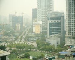
Severe Air Pollution in Hanoi: Vietnam's capital, Hanoi, topped the global list of most polluted cities, as reported by AirVisual. PM2.5 levels reached 266 micrograms per cubic meter, a dangerously high level of hazardous small particles. Causes of Pollution: Heavy traffic, industrial activities, and trash burning are the primary contributors to the city's smog. Impact on Residents: Increased respiratory problems among the elderly. Young residents report reduced visibility and discomfort while breathing. Government Response: Deputy Prime Minister Tran Hong Ha has urged a faster shift to electric vehicles (EVs). By 2030, at least 50% of buses and all taxis in Hanoi are expected to be EVs. Economic and Environmental Context: As a fast-growing economy and regional manufacturing hub, Vietnam faces significant environmental challenges in its urban centers. Significance: This situation highlights the urgent need for sustainable solutions and government interventions to combat urban pollution in rapidly developing economies. What is PM2.5 levels? PM2.5 refers to fine particulate matter with a diameter of 2.5 micrometers or smaller, small enough to penetrate deep into the lungs and even enter the bloodstream. These particles, often caused by combustion (e.g., vehicle emissions, industrial activities, and burning), pose serious health risks, including respiratory and cardiovascular diseases. 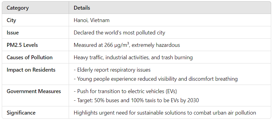
|
|
|
|
Frequently Asked Questions (FAQs) in Competitive Exams:
Q: Which city topped the global list of most polluted cities, as reported by AirVisual? A) Delhi B) Beijing C) Hanoi D) Jakarta Correct Answer: C) Hanoi Q: In the Swachh Survekshan Awards 2023, which city was declared the cleanest for the seventh consecutive year, sharing the top spot with Surat? A) Bhopal B) Indore C) Navi Mumbai D) Ahmedabad Correct Answer: B) Indore |
|
<< 5-Jan-25
|
|
|